TL;DR

Get the latest gadgets delivered free with Prime
- Fast, free delivery on millions of items
- Prime Video, Amazon Music and more included
- Member-only deals all year
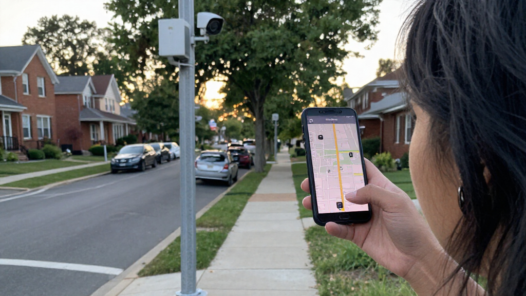
MapQuest has added an optional map layer showing locations of known outdoor surveillance cameras and license plate readers, including Flock cameras and products from several other companies. The map could help people see where devices are reported in their area, but the source does not specify how locations are verified, how often they are updated, or how complete the coverage is.
MapQuest has added a map layer showing the locations of known outdoor surveillance cameras and license plate readers, including devices made by Flock and other companies. The optional layer gives users a way to view reported camera locations in their area alongside MapQuest’s traffic and incident information, though the available report does not detail how the locations are collected or checked.
The new layer covers cameras and license plate readers from a range of manufacturers. Along with Flock, the report lists products associated with Motorola Solutions’ Vigilant, Genetec, Axis Communications, Axon, Leonardo’s ELSAG, Neology, Rekor, PlateSmart, Ubicquia and Verkada. MapQuest describes the locations as known outdoor surveillance cameras; the source does not say that every device in those product lines, or every camera in a given neighborhood, will appear.
Users can switch the layer on in the app, where it sits alongside options for traffic and incidents. MapQuest also promoted the feature with a short video set to Rockwell’s “Somebody’s Watching Me,” according to Engadget’s report. The feature is presented as a way to view camera locations, rather than as a routing tool that guarantees users can avoid them.
Engadget reported the addition amid a broader run of changes and attention for MapQuest. The service’s app had recently drawn renewed interest after it declined to call Lake Ontario “Lake America,” as Google Maps and Apple Maps had done, and it had also added Android Auto support and public transit directions. The new camera layer extends the app’s mapping features into information about surveillance infrastructure.
A Neighborhood View of Camera Networks
Displaying camera locations in a familiar map interface can make dispersed devices easier for residents to see as a network across streets and neighborhoods. For people concerned about surveillance in public spaces, the layer may help identify where devices are reported and support local discussions about their placement, use or removal. Engadget described the information as potentially useful to people trying to rid their neighborhoods of surveillance cameras.
The feature also gives users a practical, if limited, way to factor camera locations into how they understand regular routes. The report cautions that people may not be able to avoid cameras on a commute or other usual trips. A map display is not proof that a listed camera is currently operating, nor does it establish what information a device collects, who can access it, or how a particular agency uses the data. Those questions require information beyond a location layer.
For local officials and community groups, a shared map could focus attention on the geographic reach of camera deployments. Its usefulness for that purpose depends on the accuracy and freshness of the entries, details the source report does not provide. Users should treat the map as a guide to known locations, not a complete inventory or an official record.
As an affiliate, we earn on qualifying purchases.
MapQuest’s Recent App Changes
The camera display is one of several recent additions to MapQuest’s app, according to Engadget. The report describes a burst of attention following the service’s handling of the Lake Ontario naming dispute, as well as additions including Android Auto support and public transit directions. The camera layer is another option within the app, rather than a separate surveillance database described by the company.
Flock is among multiple manufacturers whose equipment is represented in the layer. The source also names companies that make or supply camera and license-plate-reader systems, including Motorola Solutions’ Vigilant and Leonardo’s ELSAG. The list signals that the feature is not limited to one brand. It does not establish that MapQuest has mapped all installations from those vendors or that every location shown is owned by a government agency.
Engadget’s report provides the feature announcement and the listed companies, but does not include technical documentation about the map data. It also does not explain whether the layer is available in every region, whether users can submit corrections, or whether the feature can be accessed in all versions of the app. Those limits matter when interpreting what a camera marker does—and does not—tell users.
“The layer shows known outdoor surveillance cameras and license plate readers.”
— MapQuest, as described in Engadget’s report
As an affiliate, we earn on qualifying purchases.
Coverage and Location Accuracy
The report does not explain where MapQuest’s camera-location data comes from, who verifies entries, or how frequently the map is updated. It is also unclear whether the layer covers every city or region, whether users can report missing or incorrect markers, and whether a listed device is confirmed to be active. The description refers to known cameras, not a complete count of all surveillance equipment.
The available information also does not describe the capabilities or operating policies of individual devices. A marker alone does not show whether a camera reads license plates, records other imagery, retains data, or shares information with other organizations. Those details vary by system and deployment and are not established by the map feature as described.
outdoor surveillance camera systems
As an affiliate, we earn on qualifying purchases.
As an affiliate, we earn on qualifying purchases.
More Details on Map Data
The feature is now described as available in MapQuest’s app, but the source report gives no specific launch date or schedule for further changes. The next useful details would be MapQuest’s explanation of its data sources, verification process and update frequency, along with information about regional availability and how users can flag errors. Until those are clarified, people using the layer should view its markers as reported locations rather than a guaranteed, exhaustive list.
Residents who want to understand a specific camera’s operation will need information from the relevant property owner, local agency or system operator. The MapQuest layer can show where a device is believed to be; the report does not say that the app provides details about its owner, purpose, data handling or oversight.
As an affiliate, we earn on qualifying purchases.
Key Questions
What does MapQuest’s new camera layer show?
It displays locations of known outdoor surveillance cameras and license plate readers, including Flock devices and products from several other listed companies.
Which camera companies are included?
The Engadget report lists Flock, Motorola Solutions’ Vigilant, Genetec, Axis Communications, Axon, Leonardo’s ELSAG, Neology, Rekor, PlateSmart, Ubicquia and Verkada.
Can the map help users avoid cameras?
It may let users see reported camera locations, but the report says people may not be able to avoid them on commutes or other usual routes. It does not describe a camera-avoidance routing option.
Are the camera locations complete and verified?
The report does not explain how locations are collected, verified or updated, and it does not claim the map is exhaustive. Treat the entries as known locations, not a complete official inventory.
Source: fediverse
Halloween Picks
halloween
As an affiliate, we earn on qualifying purchases.